Mountain hikes Holzgau - Bach - Madau

Holzgau /
Difficulty ratings: medium
Route length: 12 km

E5 variant

Tour information

  • Requirement: medium
  • Length: 12 km
  • Elevation uphill:262 hm
  • Elevation downhill:60 hm
Highest point 1,309 m

Starting point

Holzgau village square

Finishing point

Madau
  • Fitness level 3 / 6
  • Technique 2 / 6

Best time of year

  • January
  • February
  • March
  • April
  • May
  • June
  • July
  • August
  • September
  • October
  • November
  • December

Trail condition

Asphalt, forest path

Equipment

Good equipment is essential for your hike. The following items should definitely be in your rucksack: - Food and drink - Functional clothing for rain, wind and cold - A change of clothes - Sun protection - First aid kit - Mobile phone with a full battery (Euro emergency number 112) - Hiking map or GPS - Hiking poles Nevertheless, the following applies: light luggage is also easier to carry, so you should not weigh down your rucksack with unnecessary ballast. In addition, your hiking equipment should of course also be adapted to your particular hiking tour.

Description

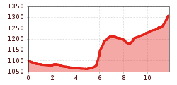
You walk alongside the Höhenbach stream to the Lech, continuing along the cycle path via Sulzbach to Stockach.
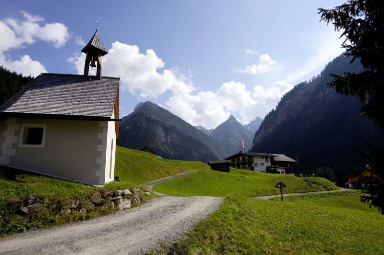
From Stockach, take the dirt track to the chapel, cross the road here and walk to the district of Winkl and then on into the Madau valley.

Getting here

  • Arrival by public transport

    Regiobus stop Holzgau village square

  • Parking

    Holzgau village square parking, subject to charge

  • Contact

    Holzgau - Bach - Madau
    ****

More tours in the surrounding area

Newsletter

The mountain is calling? So does our newsletter!

In our weekly newsletter we reveal the best holiday tips for Tyrol.