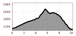
Explore a challenging hike to the Große Arnspitze, which requires a good level of fitness.

Route: Leutasch / Ahrn - Hoher Sattel - Arnspitzhütte - Große Arnspitze
Long hike that requires good physical condition.
Parking and public transport:
P6 "parking lot Hoher Sattel".
By train to Seefeld train station and continue with the Regiobus to the stop "Leutasch Ahrn".
You can find all connections in real time with the Mobility-App "wegfinder".
Directions:
The ascent to the Hohe Sattel begins in Ahrn. Once you reach the top, turn right at the hunting lodge and follow the path over the Langer Brand, climbing steadily to the Arnspitzhütte (unmanned). From here you can reach the Große Arnspitze in about 50 minutes (do not go to the right summit, this is very dangerous due to the brittle rock). The descent leads back to the Arnspitzhütte. In front of the hut, turn left in the direction of Achterköpfe Riedbergscharte and from there turn left through the forest to Unterleutasch to Gasthof Mühle. Take the bus (431) back to the starting point (bus stop "Ahrn").
Alpine emergency call:
Call: 140