Mountain hikes Gumriaul

Difficulty ratings: medium
Route length: 15.9 km
Duration: 7:30 h

Gumriaul

Tour information

  • Requirement: medium
  • Length: 15.9 km
  • Duration: 7:30 h
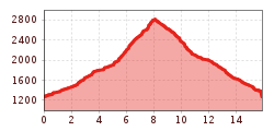
  • Elevation uphill:1,640 hm
  • Elevation downhill:1,640 hm
Highest point2,887 m

Starting point

Anras

Finishing point

Gumriaul
  • Fitness level 3 / 6
  • Technique 3 / 6

Best time of year

  • January
  • February
  • March
  • April
  • May
  • June
  • July
  • August
  • September
  • October
  • November
  • December

Description

Starting to the north of the parish church, the trail begins between two farmsteads – the Noiler and Oberhofer - then passes Noilerkapelle. Proceeding up the mountain, after some 15 minutes on the forest trail to the north of Kolls heading into Anraser Tal and to the Anraser Wiesen. Along the Mühlbach (Margarethenbach) hikers get to Anraser See and to Gumriaul.

Getting here

  • Parking

    Parkplatz Anras

More tours in the surrounding area

Newsletter

The mountain is calling? So does our newsletter!

In our monthly newsletter we reveal the best holiday tips for Tyrol.