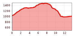
Difficulty:
easy
Length:
33.0 km
Duration:
8:00 h
Elevation uphill:
740 m
Grünberg mountain

From the car park, follow the forest road to Zwischensimmering. From there, you can join the Panorama-Rundweg trail, a panoramic circular route around Grünberg mountain. After completing about two-thirds of the trail, you will come to a junction where a path leads off to the left and takes you up to the top of the Grünberg. At the top, there is a large observation tower with wonderful 360° views of the surrounding mountains. To get back, rejoin the forest road and follow it to Zwischensimmering before continuing back down to the car park.