Difficulty:
easy
Length:
33.0 km
Duration:
8:00 h
Elevation uphill:
740 m
Burg Klamm castle and waterfall hike

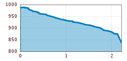
This hike starts on the road to the hamlet of Wald. Walk past the school and then continue down the steep slope to Klammermühl in the stream valley. (There are options to avoid the steep escarpment at the Spar supermarket or Cafe Schmiede). Immediately after crossing the bridge, turn left and follow the shady forest path to the footbridge. Cross back over to the left-hand bank of the stream and then continue through the forest and later across open meadows to the bridge at Burg Klamm castle. From the bridge, you can take a trail that leads to a beautiful, 25-metre-high waterfall on the Klammbach stream. This section takes just a few minutes.