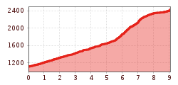
The Carnic High Trail adventure gets off to a brilliant start today. The panorama takes our breath away at times. Well, maybe it's because of the hairpin bends we're winding our way up and a little bit because of the altitude: the Sillianer Hütte is situated at 2,447 m above sea level. Once at the top, we take in the spectacular view and say goodbye to the day's guests. Because: we are staying.
Difficult stage on black mountain paths. The route requires absolute surefootedness, good walking technique and excellent fitness.

The official entry point to the Carnic altitude trail proceeds from Alpenhotel Weitlanbrunn (the hamlet of Arnbach) initially via a wide forest trail, in flat hairpin bends up to 1660 m. Leave the trail here, bearing left. From "Hofer Bankl" the Carnic altitude trail is then also the route of the local trail. Follow the trail to the forest limits and continue to Sillianer Hütte.
Further ascent options to Sillianer Hütte:
1) Via route 471 and Leckfeldalm (4 hours walking time from Sillian, 2 hours walking time from Leckfeldalm)
2) Take the Vierschach cable car via Helm (2 hours walking time from Helm mountain station)