Mountainbike-Tour Teischnitztal No. 113

Kals am Großglockner / Glocknergruppe
Difficulty ratings:
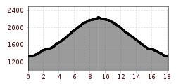
Route length: 18.2 km
Duration: 3:20 h

Teischnitztal No. 113

Tour information

  • Length: 18.2 km
  • Duration: 3:20 h
  • Elevation uphill:906 hm
  • Elevation downhill:914 hm
Highest point2,240 m

Starting point

Kals am Großglockner-Parkplatz Dorfertal (1500m)

Finishing point

Pifangalm (2250m)
  • Fitness level 4 / 6
  • Technique 4 / 6

Best time of year

  • January
  • February
  • March
  • April
  • May
  • June
  • July
  • August
  • September
  • October
  • November
  • December

Trail condition

Schotter

Description

Start at the car park in Kals Glocknerhaus, then head westside, direction to the Moaralm, 50 m before the Moaralm bridge bear right, there is a section where  you have to push the bike around 1 km before the Pifangalm; Finish: Pifangalm (not open for business),particularly lovely view to the Glockner massif.

Getting here

  • Arrival by public transport

    Kals a.G. Gemeindeamt

  • Parking

    Parkplatz Kals Zentrum

More tours in the surrounding area

Newsletter

The mountain is calling? So does our newsletter!

In our monthly newsletter we reveal the best holiday tips for Tyrol.