Mountainbike-Tour Rinner Alm - MTB route (518)

closed
Rinn/Judenstein / Tuxer Alpen
Difficulty ratings: easy
Route length: 3.7 km
Duration: 1:15 h

Rinner Alm - MTB route (518)

Tour information

  • Requirement: easy
  • Length: 3.7 km
  • Duration: 1:15 h
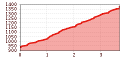
  • Elevation uphill:460 hm
  • Elevation downhill:23 hm
Highest point1,377 m

Starting point

Rinn, Oberdorf (918 m)

Finishing point

Rinner Alm (1,394 m)

Trail condition

forest road

Description

An intermediate-level local route from Rinn to the Rinner Alm mountain hut.
The route starts just past the village of Rinn and climbs steadily through the forest to the Rinner Alm. Approximately 1 km before the hut, the route becomes even steeper, allowing you to enjoy a really well-deserved break and bite to eat when you get there.
Parking is available in Rinn on Hauptstraße road or in Oberdorf.

More tours in the surrounding area

Newsletter

The mountain is calling? So does our newsletter!

In our monthly newsletter we reveal the best holiday tips for Tyrol.