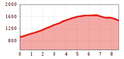
Length:
3.7 km
Duration:
1:30 h
Elevation uphill:
590 m
Mutterer Almweg (510)

A scenic and well-maintained forestry road that leads up through alpine meadows and forests to the Muttereralm.
The route starts at the car park at the bottom of the Muttereralm gondola and follows a signposted forest road steadily uphill to the Muttereralm. At the top, you will find the Mutterer Alm mountain restaurant and an adventure playground. A few metres higher up the mountain, there is a reservoir with spectacular views. The Bike Centre at the bottom lift station has rental bikes, there is a practice area at the mountain lift station and the trails at BikePark Innsbruck include a single track for beginners and advanced riders. Those who don’t want to ride trails can take the same way back.