Mountainbike-Tour Mountain bike route to Burg Klamm castle
Obsteig / Wetterstein-Gebirge and Mieminger Kette
Difficulty ratings:
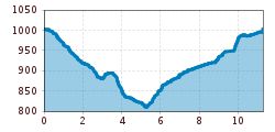
Route length: 12.0 km
Duration: 1:00 h

Mountain bike route to Burg Klamm castle

Tour information

  • Length: 12.0 km
  • Duration: 1:00 h
  • Elevation uphill:279 hm
  • Elevation downhill:283 hm
Highest point1,001 m

Starting point

Car park municipal office, Obsteig

Finishing point

Burg Klamm - castle in Obsteig

Trail condition

asphalt, gravel trail, forest road

Description

A road leads from Mötz via Burg Klamm castle, Nassereith and the Fern Pass into Germany. In the area surrounding the castle, the old road that led from Telfs up to the Mieming Plateau merges with this important arterial road. The castle is now privately owned and can only be viewed from the outside. 

Newsletter

The mountain is calling? So does our newsletter!

In our monthly newsletter we reveal the best holiday tips for Tyrol.