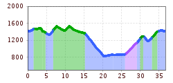
Hochgallmigg tour 758

The transport of bicycles with the cable cars in Serfaus-Fiss-Ladis is subject to a charge. More Information HERE.
Level of difficulty: hard
Starting point: Bikepark Serfaus-Fiss-Ladis
Description: The Hochgallmigg Tour poses a challenge in terms of technique and fitness. It leads from Fiss to Hochgallmigg, along the Inntal valley to Prutz and back onto the Sun Plateau.
Starting at the bike park, you follow an asphalt bike trail into the centre of Fiss heading for the Kulturhaus (F009). Bear left before the Kulturhaus and turn right at the end of the short climb (F008) in the direction of Obladis. Go past the Falterjöchl (F006) and there’s a short downhill as far as the junction (L017) and a steep descent on the bike trail to Obladis (L62). From Obladis continue on the asphalt trail to the Waldkapelle chapel. Then turn left uphill to Neuegg (L025), through the Urgtal valley onto the other side of the valley as far as Hochgallmigg. The tour follows the main road as far as Urgen, where you take the Innradweg Bike Trail heading for Prutz. Turn right 500m after the Pontlatz bridge and follow the gravel path uphill and via the Asterhöfe and the sun plateau to Ladis. In the village centre of Ladis, turn right at the church onto the Razilweg (L005) and via the Wolfsee back to the bike park in Fiss.