Grünberg (628)

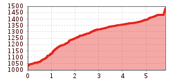
Short, brisk MTB tour from Obsteig to Grünberg with a great summit view from the observation tower overlooking the Inn Valley. From the Grünberg parking lot, walk about 200 meters, then turn left onto the forest road towards Simmering and continue straight to Zwischensimmering. At the fork in the road, turn left and continue uphill to the Grünberg observation tower and the "Sauwetterhütte" (unmanaged). The return is via the same route.
The descent follows the same path - beware of pedestrians!
After the tour, there is the option to stop at the Grünbergalm for a meal.