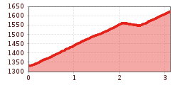
Difficulty:
medium
Length:
38.3 km
Elevation uphill:
520 m
7129 | Schnadinger Weiher

The starting point for this short but beautiful tour is the municipal office in Kaunerberg. Follow the signposted route slightly uphill and winding through the village and in a right-hand bend turn straight onto the forest path. The road, which alternates between tarmac and gravel, winds its way through lush meadows until it joins the Aifneralm route (MTB 7125). After approx. 500 metres, turn right onto the forest path. After the car park, the push track to the Schnadiger Weiher pond begins on the right on a narrow path. Another worthwhile destination is the tour to the Aifneralm (MTB 7125). The return journey follows the same route.