Mountainbike-Tour 467 Krautried

Difficulty ratings: medium
Route length: 3.3 km
Duration: 1:00 h

467 Krautried

Tour information

  • Requirement: medium
  • Length: 3.3 km
  • Duration: 1:00 h
  • Elevation uphill:350 hm
Highest point1,275 m

Starting point

car park southeast of the Seehotel St. Hubertus

Finishing point

viewpoint Krautried

Best time of year

  • January
  • February
  • March
  • April
  • May
  • June
  • July
  • August
  • September
  • October
  • November
  • December

Trail condition

gravel and forest path

Equipment

Breathable weather appropriate clothing, helmet, gloves, sunglasses, maps, repair kit and tools. For tours without opportunities for refreshments, make sure to pack sufficient food and drink.

Description

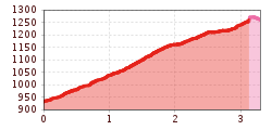
The Krautried route follows the same ascent as described in route 436 (panorama trail) before it branches off to the left. Climb the Krautried path by way of switchbacks along a scenic forest road (330 metres of elevation gain) until you arrive at the viewpoint Krautried. From here, walk your bike over the signposted section (across the ski slope) and join route 4005 – Zwölferkopf loop.

Note: The distances given indicate the length of the one-way route, as shown on the map and in the elevation profile.

Nearby huts and mountain restaurants

More tours in the surrounding area

  • Bannwaldsee circuit

    Difficulty: medium
    Length: 94.5 km Duration: 3:45 h Elevation uphill: 877 m
  • Leiterberg Trail (672)

    Opening hours: open
    Difficulty: medium
    Length: 4.7 km Duration: 0:45 h Elevation uphill: 5 m
  • Fernar Trail (6041)

    Difficulty: difficult
    Length: 6.0 km Duration: 0:49 h Elevation uphill: 18 m
  • Leithetrail 7128

    Opening hours: open
    Difficulty: easy
    Length: 4.3 km
  • Plamort Trail

    Opening hours: closed
    Difficulty: Very easy
    Length: 2.5 km
  • Buchau - Gramaialm

    Difficulty: easy
    Length: 32.9 km Duration: 3:00 h Elevation uphill: 540 m
  • Biketour Tillfussalm alpine hut

    Difficulty: easy
    Length: 9.6 km Duration: 0:54 h Elevation uphill: 174 m
  • Drauradweg

    Difficulty: easy
    Length: 63.0 km Duration: 3:30 h Elevation uphill: 50 m
  • 471 Kaltenbach - Wedelhütte

    Difficulty: medium
    Length: 36.9 km Duration: 5:00 h Elevation uphill: 1,759 m
  • Blindsee Trail

    Opening hours: closed
    Difficulty: difficult
    Length: 8.2 km Duration: 1:00 h Elevation uphill: 109 m
  • Fleckalm Trail

    Opening hours: closed
    Difficulty: difficult
    Length: 7.1 km Duration: 0:45 h
  • Milky Way

    Opening hours: closed
    Difficulty: easy
    Length: 2.9 km
  • Lechradweg

    Length: 244.6 km Duration: 18:00 h Elevation uphill: 1,702 m
  • Uphill Idalp I.3

    Difficulty: medium
    Length: 7.8 km Duration: 2:00 h Elevation uphill: 967 m
Newsletter

The mountain is calling? So does our newsletter!

In our monthly newsletter we reveal the best holiday tips for Tyrol.